The geography of Lahore Division comprises the various features relating to the land and climate. Lahore Division enjoys air, rail and road connections with rest of the country. The capital of the Punjab, Lahore has Allama Iqbal International Airport to cater the needs of District Lahore and its adjacent cities, as regular national and international flights run from here. Lahore Station is a major railway junction serving links to major cities. On the south of Lahore National Highway N-5 links Multan, on northwest and north runs Motorway M-1 and National Highway N-5 towards Gujranwala. On the west, it is linked with textile hub Faisalabad with a 4-lane highway, built on BOO (Built - Operate - Own) basis. A historical Grand Trunk Road which was a major artery during subcontinent era, originally built by Sher Shah Suri, the Afghan ruler, leads toward Indian border passing through the city.
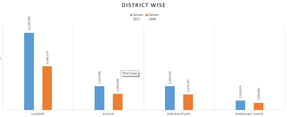
The population of Lahore Division on the basis of census conducted in 1998 and 2017 respectively are:
Lahore
The geographic of Lahore contains the assorted options with reference to the land and climate of urban center, Pakistan. Lying between 31°15′—31°45′ N and 74°01′—74°39′ E, Urban center is finite on the north and west by the Sheikhupura District, on the east by Wagah, and on the south by Kasur District. The Ravi stream flows on the northern aspect of Urban center. Urban center town covers a complete acreage of 1014 km² and continues to be growing. Urban center enjoys air, rail & road connections with remainder of the country. The Allama Iqbal International airport caters the requirements of urban center and its adjacent cities, as regular national & international flights area unit made up of here. urban center may be a major junction serving links to major cities. On the south of urban center National route N-5 links Multan, on North West & North runs superhighway M-1 and National route N-5 towards Gujranwala. On the west it's coupled with Textile town of Lyallpur with a 4-lane route, designed on BOO (Built operate & Own) basis. A historical Grand highroad that was a serious artery throughout landmass era, originally designed by Sher Shah of Iran Suri, the Afghan ruler, leads toward Indian border passing through the town.
Population
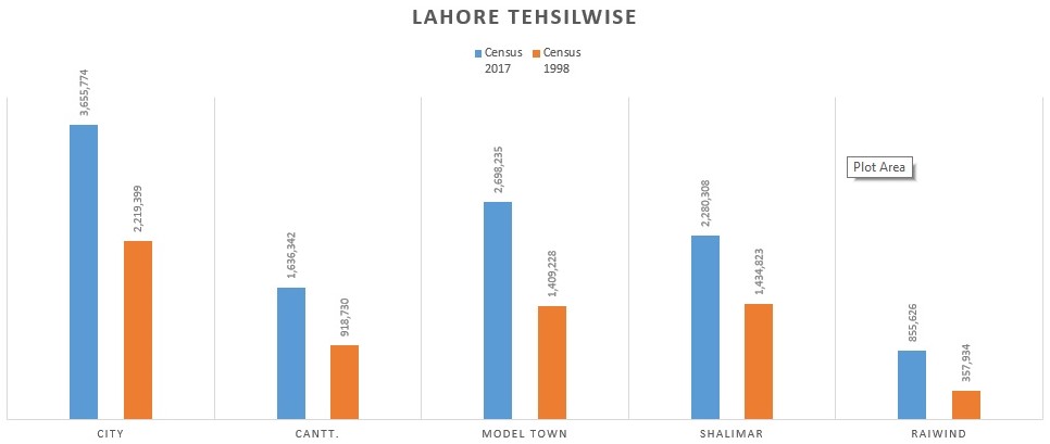
The population of District Lahore (tehsil-wise) on the basis of census conducted on 1998 and 2017 respectively is :
Kasur
Kasur is bordered to the north by Lahore and by India to the south and east. It also has borders with Okara and Nankana Sahab districts. The city is adjacent to the border of Ganda Singh Wala, a border frequently visited by people to witness the flag-lowering ceremony.
Population
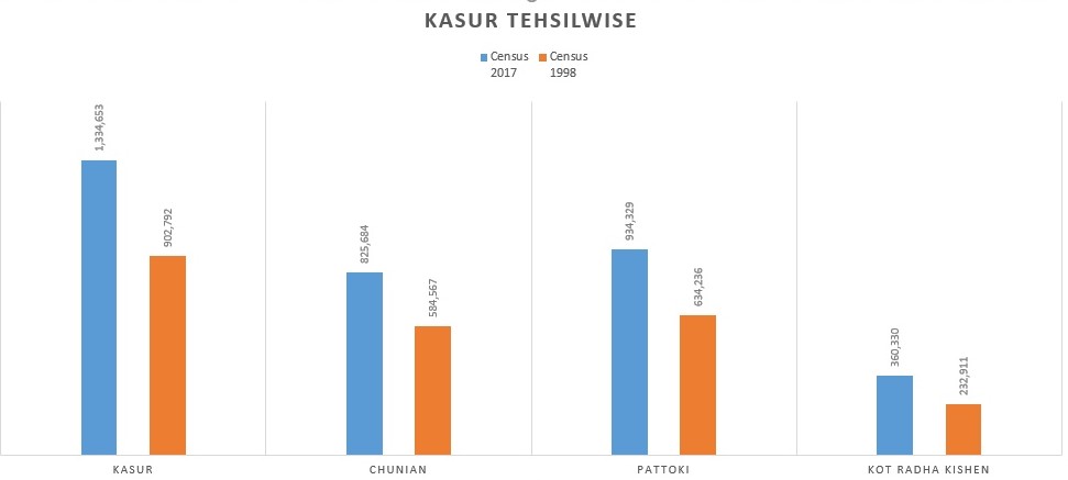
The population of District Kasur district (tehsil-wise) on the basis of census conducted in 1998 and 2017 respectively is:
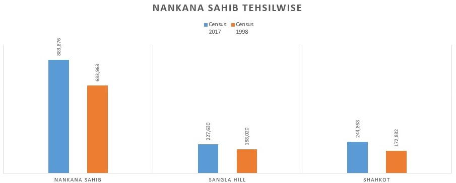
Nankana Sahib
Nankana Sahib is the seat of the District Government, and Shahkot is the largest urban center. The district of Nankana Sahib is located about 75 kilometers (47 mi) west of Lahore and about 53 kilometers (33 mi) east of Faisalabad. The area around Nankana Sahib was formerly a tehsil of Sheikhupura District. In May 2005, the Punjab government decided to raise the status of Nankana Sahib to that of a district as a way of promoting development in the area.
Population
The population of District Nankana Sahib (tehsil-wise) on the basis of census conducted in 1998 and 2017 respectively is:
Sheikhupura
Sheikhupura is an industrial center, and satellite town, located about 38 km northwest of Lahore. It is also connected to District Kasur. Geographical coordinates of the city are 31° 42’ 47″ N (latitude) and 73° 58’ 41″ E (longitude), and it is 774.27 ft. (236 m) above sea level. The city’s total area is 75 km2 (29 mi2), and the metropolitan is 3,030 km2 (1,170 mi2) in length.
Population
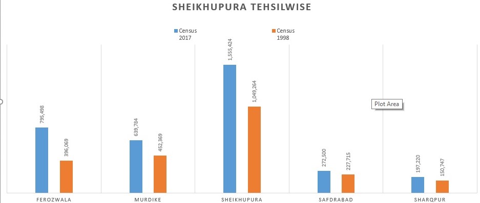
The population of District Sheikhupura (tehsil-wise) on the basis of census conducted in 1998 and 2017 respectively is: